This site may be going away; please consider the Donate link above... or LiberaPay:

A huge thank you to all who donate; 2026 Q3 Web hosting $52.02 / $300.
This site may be going away; please consider the Donate link above... or LiberaPay:
A huge thank you to all who donate; 2026 Q3 Web hosting $52.02 / $300.
![[Picture: Plan of Lynton & Lynmouth [1910]]](https://www.fromoldbooks.org/WardLockCo-LyntonAndMonmouth/pages/Lynton-01-Plan-of-Lynton-and-Lynmouth/Lynton-01-Plan-of-Lynton-and-Lynmouth-q85-500x375.jpg "[Picture: Plan of Lynton & Lynmouth [1910]]")
Buy print-size file for commercial or other use
| 500x375 | 61K | jpg free download |
| 120x90 | 4K | jpg free download |
| 267x200 | 17K | jpg free download |
| 800x600 | 142K | jpg free download |
| 1024x768 | 210K | jpg free download |
| 1600x1200 | 411K | jpg free download |
| 2178x1634 | 494K | jpg free download |
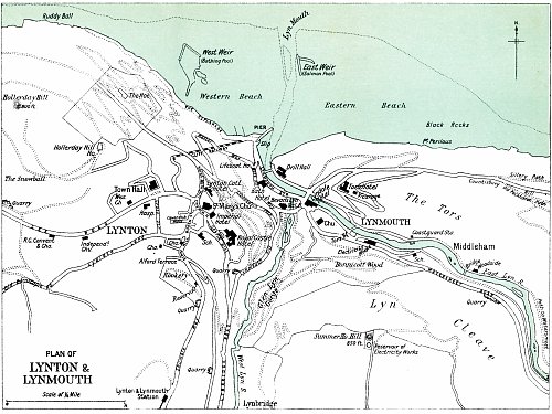
Plan of Lynton & Lynmouth [1910], in Lynton, Devonshire, England more
A map of Lynton and Lynmouth in 1910 or perhaps a little before. It spans an area from Hollerday Hill in the West to the bridge at Woodside (Middleham) and beyond to the East, and to Lynton & Lynmouth Station and Lynbridge in the South.