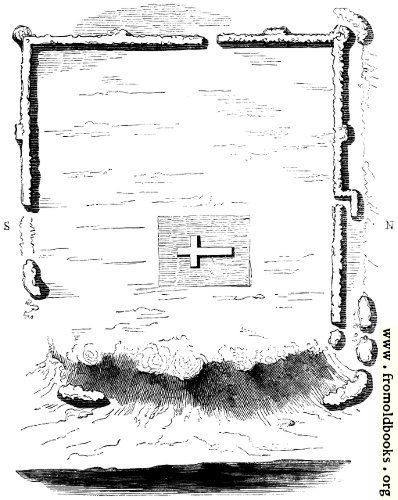
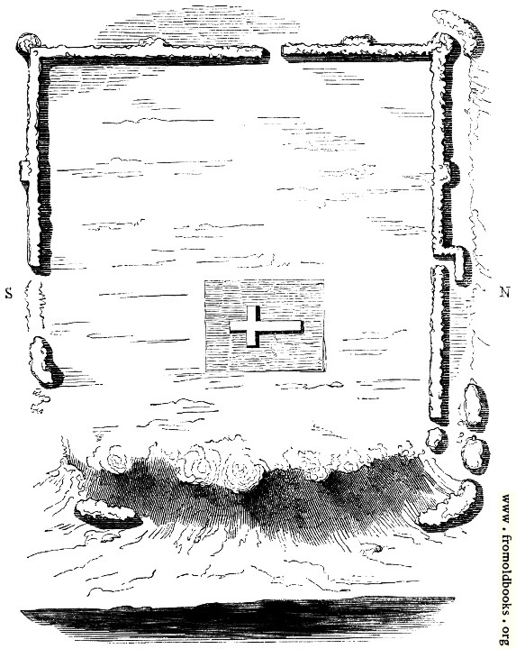
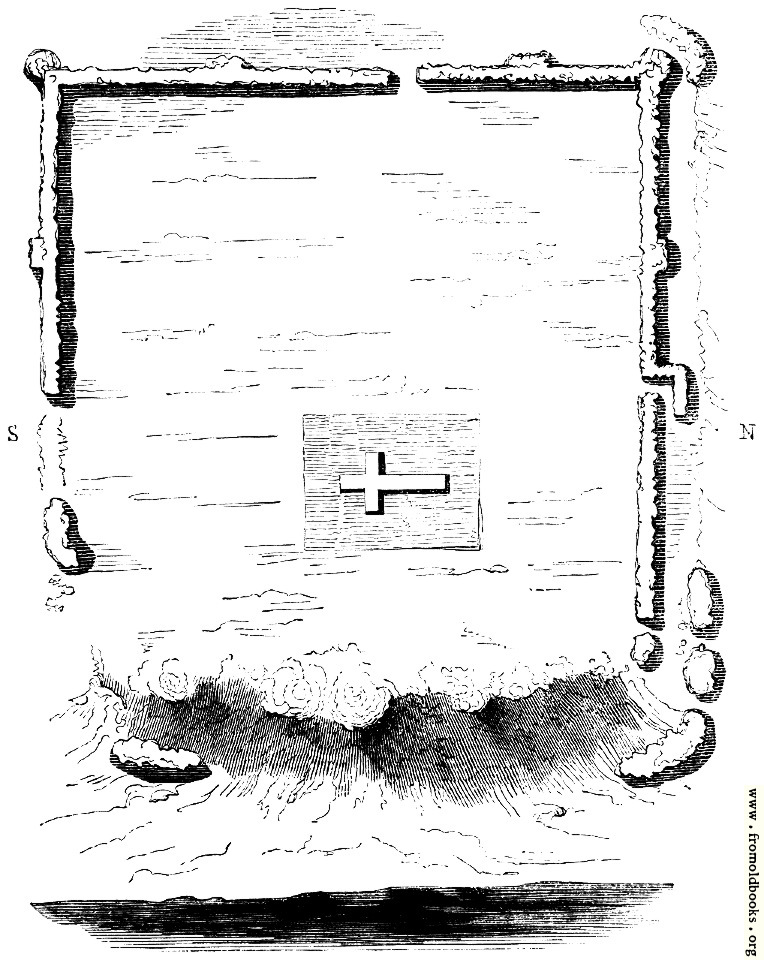
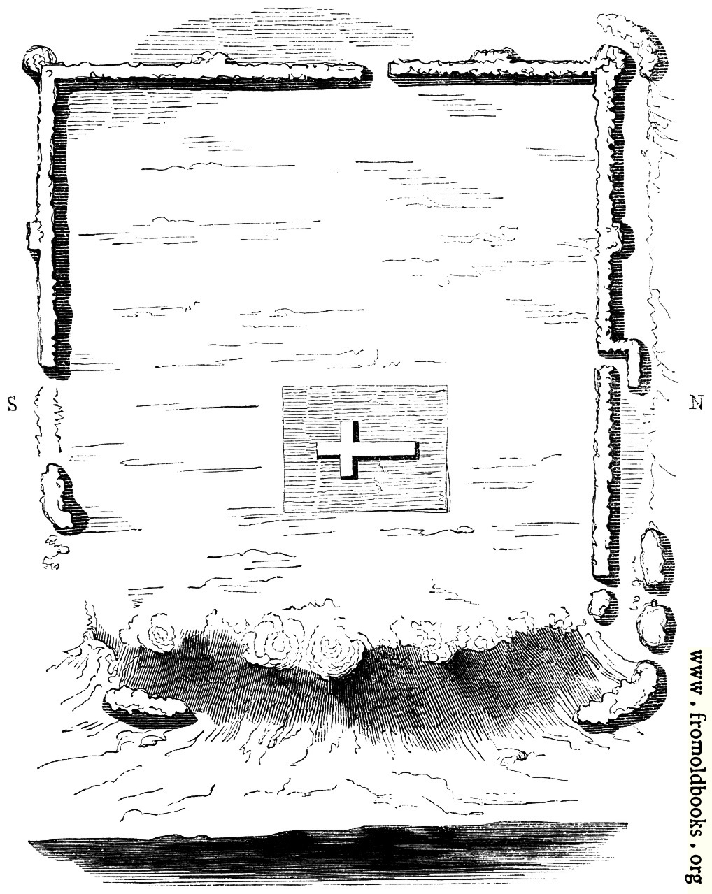
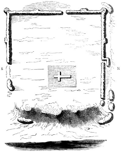
98.—Plan of Richborough.details

[Picture: 98.—Plan of Richborough.]
previous image
up

98.—Plan of Richborough., in Richborough, Kent, England more

plans, castles, ruins, roman remains


Explore

Image title:

98.—Plan of Richborough.

Taken from

Status:

Out of copyright (called public domain in the USA), hence royalty-free stock image for all purposes usage credit requested
Please do not redistribute without permission, since running this site is expensive.

Notes:


A (rather minimal) plan of Richborough castle, an ancient Roman fort on the south-east coast of England, dating to maybe A.D. 43. There is also an amphitheatre at the site. Richborough was the first Roman fort in England, and marks the start of the real invasion. The Roman name for the place was Rutupiæ. The account in the book (following) is a little confused about which parts were built when and by whom.

Ascending the narrow road which passes the cottage built at the foot of the bank, we reach some masses of wall which lie below the regular line (Plan 98). Have these fallen from their original position, or do they form an outwork connected with fragments which also appear on the lower level of the slope? This is a question not very easy to decide from the appearance of the walls themselves. Another question arises, upon which antiquarian writers have greatly differed. Was there a fourth wall on the south-eastern side facing the river? It is believed by some that there was such a wall, and that the castle or camp once formed a regular parallelogram. It is difficult to reconcile this belief with the fact that the sea has been constantly retiring from Richborough, and that the little river was undoubtedly once a noble estuary. Bede, who wrote his ’Ecclesiastical History’ in the beginning of the eighth century, thus describes the branch of the river which forms the Isle of Thanet, and which now runs a petty brook from Richborough to Reculver: “On the east side of Kent is the Isle of Thanet, considerably large, that is, containing, according to the English way of reckoning, six hundred families, divided from the other land by the river Wantsumu, which is about three furlongs over, and fordable only in two places, for both ends of it run into the sea.” Passing by the fragments of which we have spoken, we are under the north (strictly north-east) wall,—a wondrous work, calculated to impress us with a conviction that the people who built it were not the petty labourers of an hour, who were contented with temporary defences and frail resting-places. The outer works upon the southern cliff of Dover, which were run up during the war with Napoleon at a prodigious expense, are crumbling and perishing, through the weakness of job and contract, which could not endure for half a century. And here stand the walls of Richborough, as they have stood for eighteen hundred years, from twenty to thirty feet high, in some places with foundations five feet below the earth, eleven or twelve feet thick at the base, with their outer masonry in many parts as perfect as at the hour when their courses of tiles and stones were first laid in beautiful regularity. The northern wall is five hundred and sixty feet in length. From the eastern end, for more than two-fifths of its whole length, it presents a surface almost wholly unbroken. It exhibits seven courses of stone, each course about four feet thick, and the courses separated each from the other by a double line of red or yellow tiles, each tile being about an inch and a half in thickness. The entrance to the camp through this north wall is very perfect, of the construction marked in the plan. This was called by the Romans the Porta Principalis, but in after times the Postern-gate. We pass through this entrance, and we are at once in the interior of the Roman Castle. The area within the walls is a field of five acres, covered, when we saw it, with luxuriant beans, whose green pods were scarcely yet shrivelled by the summer sun. Towards the centre of the field, a little to the east of the postern-gate, was a large space where the beans grew not. The area within the walls is much higher in most places than the ground without; and therefore the walls present a far more imposing appearance on their outer side. As we pass along the north wall to its western extremity, it becomes much more broken and dilapidated; large fragments having fallen from the top, which now presents a very irregular line (Fig. 100). It is considered that at the north-west and south-west angles there were circular towers. The west wall is very much broken down; and it is held that at the opening (Plan 98) was the Decuman gate (the gate through which ten men could march abreast). The south wall is considerably dilapidated; and from the nature of the ground is at present of much less length than the north wall. Immense cavities present themselves in this wall, in which the farmer deposits his ploughs and harrows, and the wandering gipsy seeks shelter from the driving north-east rain. One of these cavities in the south wall is forty-two feet long, as we roughly measured it, and about five feet in height. The wall is in some places completely pierced through; so that here is a long low arch, with fifteen or eighteen feet of solid work, ten feet thick, above it, held up almost entirely by the lateral cohesion. Nothing can be a greater proof of the extraordinary solidity of the original work. From some very careful engravings of the external sides of the walls, given in King’s ‘Munimenta Antiqua>,’ we find that the same cavity was to be seen in 1775.

[King, Edward, 1799 – 1805, Munimenta Antiqua]

Of the early importance of Richborough we have the most decisive evidence. Bede, eleven hundred years ago, speaks of it as the chief tiling of note on the southern coast. Writing of Britain, he says, “On the south it has the Belgic Gaul; passing along whose nearest shore there appears the city called Rutubi Portus, the which port is now by the English nation corruptly called Reptacester: the passage of the sea from Gesoriacum, the nearest shore of the nation of the Morini, being fifty miles, or, as some write, four hundred and fifty furlongs.” Camden thus describes the changes in the name of this celebrated place: “On the south side of the mouth of Wantsum (which they imagine has changed its channel), and over against the island, was a city, called by Ptolemy Rhutupiæ; by Tacitus, Portus Trutulensis, for Rhutupensis, if B. Rhenanus’s conjecture hold good; by Antoninus, Rhitupis Portus; by Ammianus, Rhutupiæ statio; by Orosius, the port and city of Rhutubus; by the Saxons (according to Bede), Reptacester, and by others Ruptimuth; by Alfred of Beverley, Richberge; and at this day Richborrow: thus has time sported in varying one and the same name.” It is unnecessary for us here to enter into the question whether Rhutupiæ was Richborough, or Sandwich, or Stonar. The earlier antiquaries, Leland, Lambarde, Camden, decide, as they well might, that the great Roman Castle of Richborough was the key of that haven which Juvenal has celebrated for its oysters (Sat. iv.) and Lucan for its stormy seas (lib. vi.). Our readers, we think, will prefer, to such a dissertation, that most curious description of the place which we find in Leland’s ‘Itinerary’—a description that has been strangely neglected by most modern topographers: “Ratesburgh, otherwise Richeboro, was, or ever the river of Sture did turn his bottom or old canal within the Isle of Thanet; and by likelihood the main sea came to the very foot of the castle. The main sea is now off of it a mile, by reason of woze (ooze) that hath there swollen up. The site of the old town or castle is wonderful fair upon a hill. The walls, the which remain there yet, be in compass almost as much as the Tower of London. They have been very high, thick, strong, and well embattled. The matter of them is flint, marvellous and long bricks, white and red after the Britons’ fashion. The cement was made of sea-sand and small pebble. There is a great likelihood that the goodly hill about the castle, and especially to Sandwich-ward, hath been well inhabited. Corn groweth on the hill in marvellous plenty; and in going to plough there hath, out of mind, found, and now is, more antiquities of Roman money than in any place else of England. Surely reason speaketh that this should be Rutupinum. For beside that the name somewhat toucheth, the very near passage from Clyves, or Cales, was to Ratesburgh, and now is to Sandwich, the which is about a mile off; though now Sandwich be not celebrated because of Goodwin Sands and the decay of the haven. There is, a good flight shot off from Ratesburgh, towards Sandwich, a great dike, cast in a round compass, as it had been for fence of men of war. The compass of the ground within is not much above an acre, and it is very hollow by casting up the earth. They call the place there Lytleborough. Within the castle is a little parish church of St. Augustine, and an Hermitage. I had antiquities of the hermit, the which is an industrious man. Not far from the Hermitage is a cave where men have sought and digged for treasure. I saw it by candle within, and there were conies (rabbits). It was so straight, that I had no mind to creep far in. In the north side of the Castle is a head in the wall, now sore defaced with weather. They call it Queen Bertha Head. Near to that place, hard by the wall, was a pot of Roman money found.”

In the bean-field within the walls of Richborough there was a space where no beans grew, which we could not approach without trampling down the thick crop. We knew what was the cause of that patch of unfertility. We had learnt from the work of Mr. King, who had derived his information from Mr. Boys, the local historian of Sandwich, that there was, “at the depth of a few feet, between the soil and rubbish, a solid regular platform, one hundred and forty-four feet in length, and a hundred and four feet in breadth, being a most compact mass of masonry composed of flint stones and strong coarse mortar.” This great platform, “as hard and entire in every part as a solid rock,” is pronounced by King to have been “the great parade, or Augurale, belonging to the Prætorium, where was the Sacellum for the eagles and ensigns, and where the sacrifices were offered.” But upon this platform is placed a second compact mass of masonry, rising nearly five feet above the lower mass, in the form of a cross, very narrow in the longer part which extends from the south to the north (or, to speak more correctly, from the south-west to the north-east), but in the shorter transverse of the cross, which is forty-six feet in length, having a breadth of twenty-two feet. This cross, according to King, was the site of the Sacellum. Half a century ago was this platform dug about and under, and brass and lead, and broken vessels were found, and a curious little bronze figure of a Roman soldier playing upon the bagpipes (Fig. 102). Again has antiquarian curiosity been set to work, and labourers are now digging and delving on the edge of the platform, and breaking their tools against the iron concrete. The workmen have found a passage along the south and north sides of the platform, and have penetrated, under the platform, to walls upon which it is supposed to rest, whose foundations are laid twenty-eight feet lower. Some fragments of pottery have been found in this last excavation, and the explorers expect to break through the walls upon which the platform Tests, and find a chamber. It may be so. Looking at the greater height of the ground within the walls, compared with the height without, we are inclined to believe that this platform, which is five feet in depth, was the open basement of some public building in the Roman time. To what purpose it was applied in the Christian period, whether of Rome or Britain, we think there can be no doubt. The traveller who looked upon it three centuries ago tells us distinctly, “within the Castle is a little parish church of St. Augustine, and an hermitage.” When Camden saw the place, nearly a century after Leland, the little parish church was gone. He found no hermitage there, and no hermit to show him antiquities. He says, “To teach us that cities die as well as men, it is at this day a corn-field, wherein when the corn is grown up one may observe the draughts of streets crossing one another, for where they have gone the corn is thinner.... Nothing now remains but some ruinous walls of a square tower cemented with a sort of sand extremely binding.” He also says that the crossings of the streets are commonly called St. Augustine’s Cross. There is certainly some confusion in this description of crossings as one cross. To us it appears more than probable that the “little parish church of St. Augustine,” which Leland saw, had this cross for its foundation, and that when this church was swept away—when the hermit who dwelt there, and there pursued his solitary worship, fell upon evil times—the cross, with a few crumbling walls, proclaimed where the little parish church had stood, and that this was then called St. Augustine’s Cross (Fig. 101). The cross is decidedly of a later age than the platform: the masonry is far less regular and compact. Camden, continuing the history of Richborough after the Romans, says, “This Rutupiæ flourished likewise after the coming in of the Saxons, for authors tell us it was the palace of Ethelbert, king of Kent, and Bede honours it with the name of a city.” The belief that the palace of Ethelbert was upon this commanding elevation, so strengthened by art, full no doubt of remains of Roman magnificence, the key of the broad river which allowed an ample passage for ships of burthen from the Channel to the estuary of the Thames, is a rational belief. But Lambarde says of Richborough, “Whether it were that palace of King Ethelbert from whence he went to entertain Augustine, he that shall advisedly read the twenty-fifth chapter of Beda his first book shall have just cause to doubt; forasmuch as he showeth manifestly that the king came from his palace into the Isle of Thanet to Augustine, and Leland saith that Richborough was then within Thanet, although that since that time the water has changed its old course and shut it clean out of the island.” This is a refinement in the old Kentish topographer which will scarcely outweigh the general fitness of Richborough for the palace of the Saxon king. The twenty-fifth chapter of Bede is indeed worth reading “advisedly;” but not to settle this minute point of local antiquarianism. (p. 31)

English Heritage Web Page for Richborough


Keywords:

Place shown:

Filename:

tn/0098-Plan-of-Richborough-q85-398x500.jpg

Scanner dpi:

2400 dots per inch

Comment:

Download:

Similar images: