This site may be going away; please consider the Donate link above... or LiberaPay:

A huge thank you to all who donate; 2026 Q3 Web hosting $52.02 / $300.
This site may be going away; please consider the Donate link above... or LiberaPay:
A huge thank you to all who donate; 2026 Q3 Web hosting $52.02 / $300.
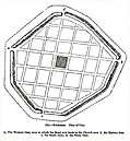
![[Picture: 125.—Silchester. Plan of City.]](https://www.fromoldbooks.org/OldEngland/pages/0125-Silchester-plan-of-city/0125-Silchester-plan-of-city-463x500.jpg "[Picture: 125.—Silchester. Plan of City.]")
Buy print-size file for commercial or other use
| 463x500 | 37K | jpg free download |
| 119x129 | 3K | jpg free download |
| 185x200 | 5K | jpg free download |
| 897x968 | 113K | jpg free download |
| 1196x1290 | 147K | jpg free download |
125.—Silchester. Plan of City., in Silchester, Hampshire, England more
a, The Western Gate, near to which the Road now leads to the church near b, the Eastern Gate; c, the South Gate; d, the North Gate.
Silchester was a Romantown in England.