This site may be going away; please consider the Donate link above... or LiberaPay:

A huge thank you to all who donated in 2025; 2026 Q1 Web hosting 0 / $400; planning a move to much cheaper hosting this quarter.
This site may be going away; please consider the Donate link above... or LiberaPay:
A huge thank you to all who donated in 2025; 2026 Q1 Web hosting 0 / $400; planning a move to much cheaper hosting this quarter.
![[Picture: Cambridgeshire]](https://www.fromoldbooks.org/Grose-Antiquities/pages/Cambridgeshire/Cambridgeshire-q75-500x420.jpg "[Picture: Cambridgeshire]")
Buy print-size file for commercial or other use
| 500x420 | 74K | jpg free download |
| 119x100 | 5K | jpg free download |
| 238x200 | 19K | jpg free download |
| 784x658 | 151K | jpg free download |
| 1045x878 | 254K | jpg free download |
| 1393x1170 | 422K | jpg free download |
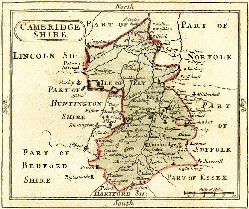
A public domain map of the County of Cambridgeshire in England, from 1783.
Places marked on the map include the following: Abbingtons, Arrington, Audre, Batsham, Bedelhey, Bigleswade (Bedfordshire), Boxworth, Burwells, Bury (Huntingtonshire [sic]), Cambridge, Castle Camps, Caxton, Charleton, Chateres, Cheveley, Cottenham, Croyland (shown on the border with Lincolnshire), Ditton, Dodham, Dounham (Norfolk), Downham, Elme, Ely, Erith (Huntingtonshire [sic]), Fubner, Gransdens, Graveley, Gyhern, Hadenham, Harlston, Harlton, Haverill (Suffolk), Helgey (Norfolk), Huntinton (Huntingtonshire [sic]), Ile of Ely [Isle of Ely, a region], Istam, Kennet, Knapwel, Linton, Littleport, Longstanton, Lowbworth, Lylyngton, Marshe Wimlingon, Melborn, Mildenhall (Suffolk), Mylton, Newmarket, Offordes (Huntingtonshire [sic]), Outwel, Pesomdrove, Peterborough (shown on the border with Lincolnshire), Potton (Bedfordshire), Presthouse (Norfolk), Ramsay (Huntingtonshire [sic]), Roche, Royston (on the border with “Hartford Shire”), Salterslode (Norfolk), Sawsten, Singlewell, Soham, Somersham (Huntingtonshire [sic]), Southrey (Norfolk), Stantney, Stapleford, St. Gylestyde, St. Ives (Huntingtonshire [sic]), St. Maries, St. Neot (Huntingtonshire [sic]), Sutton, Tadlow, Thorney, Tofte, Upwell, Walsoken (Norfolk), Walton, Walton (Norfolk), Welney, Whieelesey, Wickham, Wilbrahams, Wisbich, Wistow (Huntingtonshire [sic]), Wormleighton (Suffolk) and Yuxley (Huntingtonshire [sic])