This site may be going away; please consider the Donate link above... or LiberaPay:

A huge thank you to all who donate; 2026 Q3 Web hosting $52.02 / $300.
This site may be going away; please consider the Donate link above... or LiberaPay:
A huge thank you to all who donate; 2026 Q3 Web hosting $52.02 / $300.
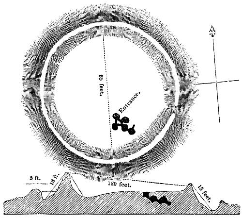
![[Picture: 54.—Ground Plan and Section of the Subterranean Chamber at Carrighhill.]](https://www.fromoldbooks.org/OldEngland/pages/0054-Carrighhill-Plan-and-Section/0054-Carrighhill-Plan-and-Section-q75-500x449.jpg "[Picture: 54.—Ground Plan and Section of the Subterranean Chamber at Carrighhill.]")
Buy print-size file for commercial or other use
| 500x449 | 53K | jpg free download |
| 119x107 | 3K | jpg free download |
| 223x200 | 8K | jpg free download |
| 923x829 | 154K | jpg free download |
| 1230x1105 | 222K | jpg free download |
54.—Ground Plan and Section of the Subterranean Chamber at Carrighhill., in Carrick-on-Suir, County Tipperary, Ireland more
I think the place mentioned is probably Carrick, and in particular either the neolithic Carrick East Burial Chamber or Carrigadoon Hill, but I am not certain. At any rate the text makes clear that it is in Ireland, but says nothing more. The cited archaeological report mentions Fermoy in its title (the contents are online).